SWRO Desalination Plant Siting
Western Headland W2 · 44.933°E · 8.6 km from urban core · not airport side · score 4.70/5.0
NB19 extended the siting analysis to 9 criteria and identified a subsurface gallery intake at the Wadi Calinuur estuary (44.680°E) that eliminates UF pre-treatment entirely and achieves zero marine entrainment. W2 Western Headland (this page) is superseded. See NB19 — Carabeyto Calinuur SWRO Site.
The provisional SWRO site at [45.055°E] was on the airport corridor side (Z4 Eastern Strip) — contrary to planning requirements. NB18 runs a 6-criteria weighted siting analysis across 4 candidates. The recommended site is W2 Western Headland at 44.933°E, 10.462°N: 8.6 km west of the urban core, on the open Gulf of Aden coast, away from both the urban area and the airport corridor. Score: 4.70/5.0 vs 2.65/5.0 for the rejected E1.
Multi-Criteria Siting Analysis
Six weighted criteria scored 1–5 across four candidate sites. Airport corridor avoidance (20% weight) immediately eliminates E1. Water quality (25%) and urban distance (20%) drive W2 above W3. Pipeline cost (10%) keeps W3 from winning despite its greater distance.
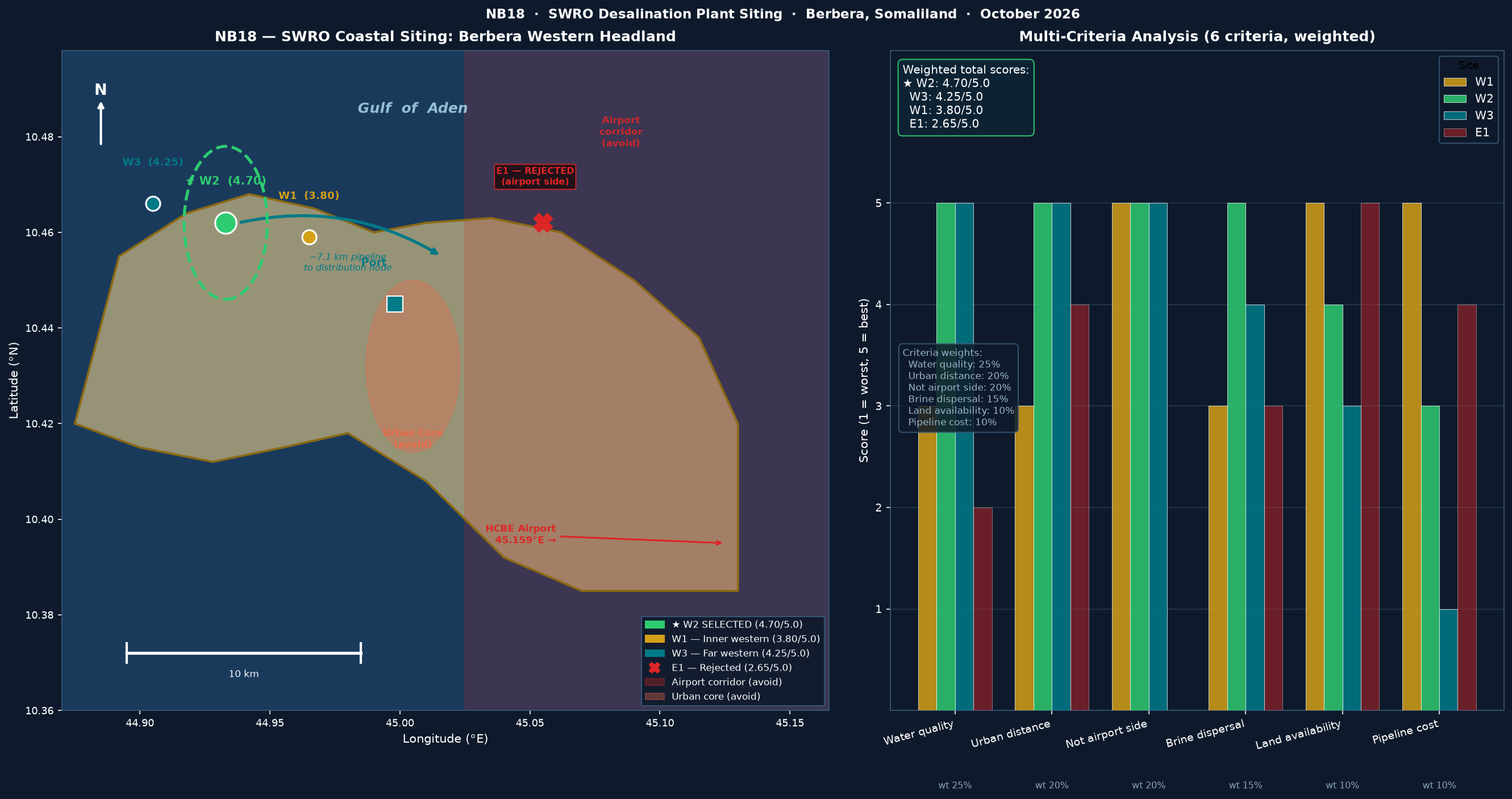
NB18 · October 2026 · 6-criteria weighted analysis · Peninsula schematic from known coordinates
Candidate Site Comparison
| Site | Location | Dist. urban | Airport side? | Score |
|---|---|---|---|---|
| W2 ★ | 44.933°E — Western Headland | 8.6 km | No — open Gulf coast | 4.70/5.0 |
| W3 | 44.905°E — Far Western Coast | 11.6 km | No | 4.25/5.0 |
| W1 | 44.965°E — Inner Western Coast | 5.3 km | No | 3.80/5.0 |
| E1 ✗ | 45.055°E — Eastern Strip (old) | 6.4 km | YES — rejected | 2.65/5.0 |
Scoring criteria (weighted)
| Criterion | Weight | W2 score | Rationale |
|---|---|---|---|
| Water quality | 25% | 5/5 | Open Gulf of Aden — no port or urban runoff influence |
| Urban distance (≥4km) | 20% | 5/5 | 8.6km — well above the 4km threshold |
| Not airport side | 20% | 5/5 | West of urban core; airport (HCBE) is 26km east |
| Brine dispersal | 15% | 5/5 | Open coast; Gulf westward current disperses plume offshore |
| Land availability | 10% | 4/5 | 70ha coastal flat; slight terrain relief on headland |
| Pipeline cost | 10% | 3/5 | 7.1km to distribution node — moderate; W1 closer but water quality lower |
Why W2 Western Headland
The western coast faces the open Gulf of Aden with no harbour influence, port traffic, or urban runoff. Salinity is stable at ~35.5 g/L (vs harbor values of 36–38 g/L due to evaporation). Lower suspended solids reduces pre-treatment cost (UF membranes) and extends RO membrane life.
The Gulf of Aden has a dominant westward surface current (~0.5–0.8 m/s). Brine discharged at W2 (60 g/L concentrate) is swept westward away from the city and diluted rapidly. A 300m offshore diffuser at 25m depth achieves <39 g/L within 500m of discharge.
SWRO plants generate noise (intake pumps, ERDs, chemical storage) and visual impact. The 8.6km separation places W2 well outside the 4km noise/odour buffer typical for Gulf SWRO plants. The site is outside the urban planning boundary and requires no resettlement.
HCBE Berbera International Airport is at 45.159°E — the eastern end of the planning area. Zone Z3 "Airport & Industrial Corridor" and Z4 "Eastern Coastal Strip" are reserved for port logistics, industrial estates, and tourism. W2 (44.933°E) is firmly in the western coastal lowland, compatible with Z2 industrial coastal use.
Plant Design Parameters — W2 Site
Intake System
RO Process
Brine & Outfall
W2 Site Location — Live Map
W2 Western Headland at 44.933°E, 10.462°N — 8.6 km west of urban core, 7.4 km west of port. The 70 ha plant footprint (1,000 m × 700 m) is shown as the polygon. Toggle satellite imagery to view coastal terrain and land cover. Click the site marker for properties.
Pipeline & Energy Connection
| Route segment | Length | Specification |
|---|---|---|
| SWRO W2 → coastal trunk junction | 7.1 km | DN1000 mm, coastal flat, gravity-assisted |
| Coastal trunk → Berbera city header | 3.2 km | DN1200 mm, existing alignment NB12 |
| City header → Z1 Urban Core | 2.5 km | DN800 mm distribution main |
| Coastal trunk → Sheikh pipeline off-take | 2.8 km | DN1000 mm, joins highland gravity line |
| TOTAL to distribution | ~16 km | All coastal alignment, no mountain tunnels |
NB18 confirmed the dam site at 1,395m ASL. This creates a gravity-flow opportunity to Hargeisa (1,334m) — 61m head over 115.3km (grade 0.53‰). The D3 Hargeisa gravity main (DN900 HDPE PE100, 115.3km) was added to the NB12 pipeline network with no pumping required. Capacity: 110,000 m³/day. Phase 2 demand: 56,000 m³/day (Hargeisa, 700k pop.).
W2 is 8.6km west of the main solar farm grid connection at SS-01. A 33kV spur from the coastal grid ring serves the SWRO plant. Phase 3 SWRO load: 500,000 m³/day × 3.5 kWh/m³ = 72.9 MW. The NB11 solar system (963 MW total) has capacity to serve this load. Dedicated SWRO substation (SS-SWRO): 132 kV / 33 kV, 100 MVA.
- · Bathymetric survey (MBES) at W2 — confirm 25m depth within 200m
- · Coastal current survey (ADCP, 12 months) — confirm westward drift pattern
- · Marine ecology baseline — coral, seagrass, fisheries within 1km
- · Geotechnical: substrate type for intake pipe trench
- · Brine dispersion modelling (CORMIX or MIKE 21)